Earthworks Takeoff Software | Improve Cut & Fill Accuracy Fast
By Sai Vamshi in Blog Posted June 8, 2026 Tags earthworks software,Earthworks takeoff software
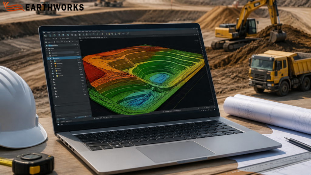
What Is Earthworks Takeoff Software and How Does It Work?
If you work on construction estimation, you already know how critical accuracy is when planning excavation, grading, and site preparation. So what exactly is Earthworks takeoff software, and why is it increasingly used in modern construction workflows?
Simply put, it is a digital tool used to measure, calculate, and estimate soil movement quantities—such as cut, fill, and grading—directly from construction drawings or site plans with high accuracy.
Instead of manual measurement, it automates calculations and helps contractors produce more consistent estimation outputs in construction projects.
What Is Earthworks in Construction?
Earthworks takeoff software is used to support calculation of cut, fill, and grading quantities from design drawings during early-stage estimation.
It typically includes:
- Site clearing and grading
- Excavation for foundations
- Road and infrastructure preparation
- Landscaping and leveling
- Cut-and-fill balancing
In simple terms: It is used to calculate cut, fill, and grading quantities directly from construction drawings.
What Does Earthworks Takeoff Software Actually Do?
Earthworks takeoff software calculates material quantities from digital construction drawings using automated measurement workflows.
Direct answer:
It measures cut and fill volumes by analyzing terrain surfaces and elevation data from construction drawings.
This eliminates manual calculations and helps reduce manual calculation errors.
How Does Earthworks Takeoff Software Work?
The process is structured and data-driven:
- Import CAD drawings or PDF site plans
- Define site boundaries and existing terrain
- Mark proposed grading or design surfaces
- Software calculates cut, fill, and total volume differences
- Generate reports for cost estimation and planning
Why Is Earthworks Takeoff Software Important?
Construction bidding is highly competitive, and even small errors in estimation can lead to major financial loss.
Here’s why this software matters:
- Improves Estimation Accuracy
It reduces human error in calculating soil volumes and elevation differences.
- Speeds Up Bid Preparation
Estimates that used to take days can now be completed in hours.
- Project Planning Workflows
Contractors can better plan equipment, labor, and material usage.
- Supports Cost Planning
Accurate cut-and-fill data supports better cost planning and helps reduce unexpected site costs.
- Supports Better Decision-Making
Teams can compare design options and optimize Earthworks strategies.
What Problems Does It Solve in Real Projects?
Problem: Manual measurement errors
Even small mistakes in elevation readings can distort total cost.
Solution:
Automated calculations help reduce errors in quantity takeoffs.
Problem: Delayed bidding process
Digital takeoff workflows help speed up bid preparation.
Solution:
Digital tools speed up the entire planning workflows.
Problem: Unclear terrain understanding
3D tools help visualize terrain from design drawings.
Solution:
3D visualization provides a clear view of site conditions.
Problem: Budget uncertainty
More consistent quantity calculations support cost planning.
Solution:
More precise volume calculations support better financial planning and control
Who Uses Earthworks Takeoff Software?
This technology is used across multiple construction roles:
- Civil engineers
- Estimators and quantity surveyors
- Construction project managers
- Earthmoving contractors
- Infrastructure developers
Even small contractors working on Earthworks projects now use it to stay competitive in bidding.
Is It Only Useful for Large Construction Companies?
No, and this is a common misconception.
While large firms were early adopters, smaller businesses now benefit equally because:
- Bid competition is tighter
- Clients expect faster estimates
- Margins are more sensitive
- Accuracy directly impacts profitability
Even small-scale Earthworks projects like residential grading or local roadworks benefit from digital takeoff tools.
What Features Make Good Earthworks Takeoff Software?
Not all tools offer the same level of precision or usability.
Key features to look for:
- 2D and 3D terrain modeling
- Automated cut and fill calculations
- CAD file compatibility
- Real-time measurement updates
- Custom reporting for bids
- Cloud-based collaboration tools
The goal is not just automation—but reliable, repeatable accuracy in Earthworks estimation.
Can It Fully Replace Manual Estimation?
No, but it significantly reduces reliance on manual work.
Clear answer:
It automates major calculation tasks, but human expertise is still needed for interpretation, assumptions, and site-specific adjustments.
So instead of replacing estimators, it enhances their efficiency.
Why Is It Becoming Industry Standard?
Construction workflows are increasingly using digital tools for estimation, measurement, and reporting. Earthworks takeoff software is used in these workflows for quantity calculation from drawings.
Final Answer: Is Earthworks Takeoff Software Worth It?
Yes—especially for any contractor involved in excavation, grading, or site preparation.
To summarize:
Earthworks takeoff software is a digital estimation tool that calculates cut, fill, and grading volumes from construction drawings to support estimation workflows in construction projects.
For modern site preparation projects, it is no longer just a convenience—it is a competitive necessity.
READ MORE
Recent Comments